Tag: pixels

Pixel Maps in R

Pixel Maps in R

Those of you who follow my blog know I love world maps. Particularly when they are used to visualize data, like these maps of Kaggle programming language preferencesUS household incomes, rush hour travel times, or Shazam recognitions. Those who share this passion will probably like this blog’s topic: mapping data to pixel maps! In R obviously!

A pixel map of holiday and living locations made by Taras Kaduk in R [original]

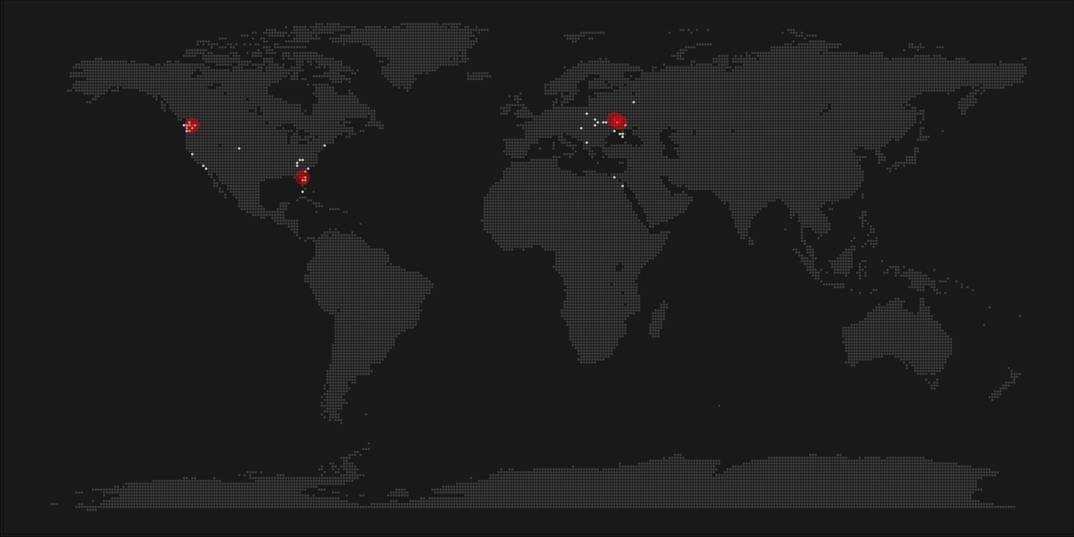
Taras Kaduk seems as excited about R and the tidyverse as I am, as he built the beautiful map above. It flags all the cities he has visited and, in red, the cities he has lived. Taras was nice enough to share his code here, in the original blog post.

Now, I am not much of a globetrotter, but I do like programming. Hence, I immediately wanted to play with the code and visualize my own holiday destinations. Below you can find my attempt. The updated code I also posted below, but WordPress doesn’t handle code well, so you better look here.

worlmap_dots
The code to make your own map you can find here.

Let’s run you through the steps to make such a map. First, we need to load some packages. I use the apply family to install and/or load a set of packages so that if I/you run the script on a different computer, it will still work. In terms of packages, the tidyverse (read more) includes some nice data manipulation packages as well as the famous ggplot2 package for visualizations. We need maps and ggmap for their mapping functionalities. here is a great little package for convenient project management, as you will see (read more).

### setup ----------------------------------------------------------------------

# install and/or load packages
pkg <- c("tidyverse", "maps", "ggmap", "here")
sapply(pkg, function(x){
  if(! x %in% installed.packages()) install.packages(x)
  require(x, character.only = TRUE)
})

Next, we need to load in the coordinates (longitudes and latitudes) of our holiday destinations. Now, I started out creating a dataframe with city coordinates by hand. However, this was definitely not a scale-able solution. Fortunately, after some Googling, I came across ggmap::geocode(). This function allows you to query the Google maps API(no longer works) Data Science Toolkit, which returns all kinds of coordinates data for any character string you feed it.

Although, I ran into two problems with this approach, this was nothing we couldn’t fix. First, my home city of Breda apparently has a name-city in the USA, which Google favors. Accordingly, you need to be careful and/or specific regarding the strings you feed to geocode() (e.g., “Breda NL“). Second, API’s often have a query limit, meaning you can only ask for data every so often. geocode() will quickly return NAs when you feed it more than two, three values. Hence, I wrote a simple while loop to repeat the query until the API retrieves coordinates. The query will pause shortly in between every attempt. Returned coordinates are then stored in the empty dataframe I created earlier. Now, we can easily query a couple dozen of locations without errors.

You can try it yourself: all you need to change is the city_name string.

### cities data ----------------------------------------------------------------

# cities to geolocate
city_name <- c("breda NL", "utrecht", "rotterdam", "tilburg", "amsterdam",
               "london", "singapore", "kuala lumpur", "zanzibar", "antwerp",
               "middelkerke", "maastricht", "bruges", "san fransisco", "vancouver", 
               "willemstad", "hurghada", "paris", "rome", "bordeaux", 
               "berlin", "kos", "crete", "kefalonia", "corfu", 
               "dubai", " barcalona", "san sebastian", "dominican republic", 
               "porto", "gran canaria", "albufeira", "istanbul", 
               "lake como", "oslo", "riga", "newcastle", "dublin", 
               "nice", "cardiff", "san fransisco", "tokyo", "kyoto", "osaka",
               "bangkok", "krabi thailand", "chang mai thailand", "koh tao thailand")   

# initialize empty dataframe   
tibble( 
  city = city_name, 
  lon = rep(NA, length(city_name)), 
  lat = rep(NA, length(city_name)) 
) ->
  cities

# loop cities through API to overcome SQ limit
# stop after if unsuccessful after 5 attempts
for(c in city_name){
  temp <- tibble(lon = NA)
  # geolocate until found or tried 5 times
  attempt <- 0 # set attempt counter
  while(is.na(temp$lon) & attempt < 5) {
    temp <- geocode(c, source = "dsk")
    attempt <- attempt + 1 
    cat(c, attempt, ifelse(!is.na(temp[[1]]), "success", "failure"), "\n") # print status
    Sys.sleep(runif(1)) # sleep for random 0-1 seconds
  } 
  # write to dataframe
  cities[cities$city == c, -1] <- temp
}

Now, Taras wrote a very convenient piece of code to generate the dotted world map, which I borrowed from his blog:

### dot data -------------------------------------------------------------------

# generate worldwide dots
lat <- data_frame(lat = seq(-90, 90, by = 1))
lon <- data_frame(lon = seq(-180, 180, by = 1))
dots <- merge(lat, lon, all = TRUE)  
# exclude water-based dots 
dots %>%
mutate(country = map.where("world", lon, lat),
       lakes = map.where("lakes", lon, lat)) %>%
  filter(!is.na(country) & is.na(lakes)) %>% 
  select(-lakes) ->
  dots

With both the dot data and the cities’ geocode() coordinates ready, it is high time to visualize the map. Note that I use one geom_point() layer to plot the dots, small and black, and another layer to plot the cities data in transparent red. Taras added a third layer for the cities he had actually lived in; I purposefully did not as I have only lived in the Netherlands and the UK. Note that I again use the convenient here::here() function to save the plot in my current project folder.

### visualize ------------------------------------------------------------------

# plot the data
dots %>% ggplot(aes(x = lon, y = lat)) + 
  geom_point(col = "black", size = 0.25) +
  geom_point(data = cities, col = "red", size = 3, alpha = 0.7) + 
  theme_void() +
  theme(
    panel.background = element_rect(fill = "#006994"),
    plot.background = element_rect(fill = "#006994")
  ) -> dot_map

# save plot
ggsave(here("worlmap_dots.png"), dot_map, 
       dpi = 600, width = 8, height = 4.5)


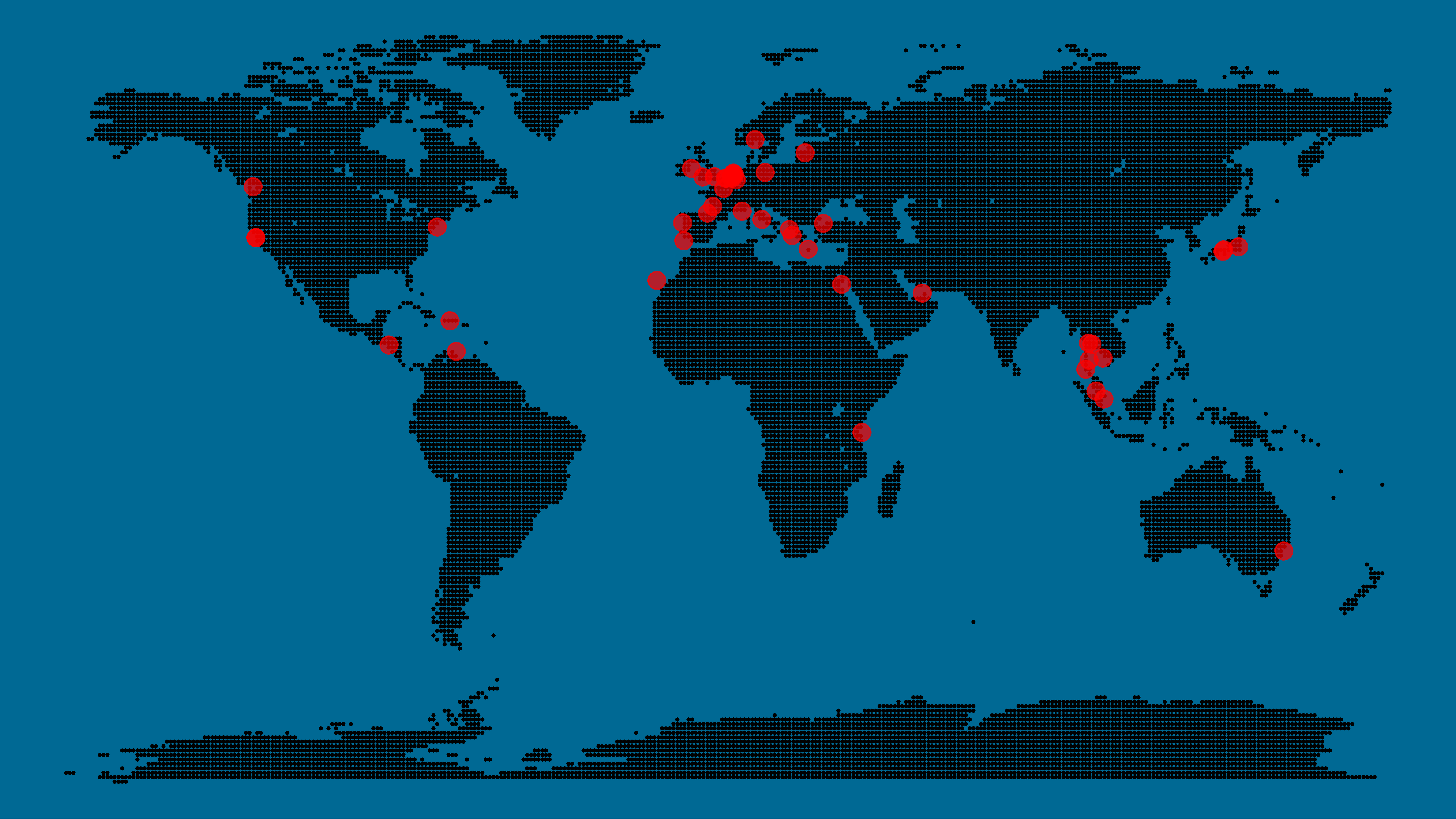
I very much like the look of this map and I’d love to see what innovative, other applications you guys can come up with. To copy the code, please look here on RPubs. Do share your personal creations and also remember to take a look at Taras original blog!

Super Resolution: Increasing image quality CSI-like

Super Resolution: Increasing image quality CSI-like

Super-resolution imaging is a class of techniques that enhance the resolution of an imaging system (Wikipedia). The entertainment series CSI has been ridiculed for relying on exaggerated and unrealistic applications of it:

giphy

Until recently, such upscaling of images were though near impossible. However, we have evidenced some pretty amazing breakthroughs in the deep learning space recently. Artificial Intelligence can think ahead, learn physics, and beat experts at their own games (DOTA; Poker), mostly through inventive applications of neural networks.

As a result, there are now several applications where machines have learned to literally fill in the blanks in imagery. Most notable seems the method developed by Google: Rapid and Accurate Image Super Resolution, or RAISR is short. In contrast to other approaches, RAISR does not rely on (adversarial) neural network(s) and is thus not as resource-demanding to train. Moreover, it’s performance is quite remarkable:

Google RAISR SurferYou can read more details in the paper by Romano, Isodoro, and Milanfar (2016) or watch the research summary below by, unsurprisingly, Two Minute Papers:

I guess you’re eager to test this super resolution out yourself?! letsenhance.io let’s you enhance the resolution of five images for free, after which it charges you $5 per twenty pictures processed. The website feeds the input image to a neural net and puts out an image of which the resolution has been increased four fold! I tested it with this random blurry picture I retrieved from Google/Pinterest.

blurry_picture
Original 500×500

blurry_picture-magic
Enhanced 2000×2000

Do you see how much more detailed (though still blurry) the second image is? Nevertheless, upscaling four times seems about the limit as that is the default factor for both RAISR and Let’s Enhance. I am very curious to see how this super resolution is going to develop in the future, how it will be used to decrease memory or network demands, whether it will be integrated with video platforms like YouTube or Netflix, and which algorithm will ultimately take the crown!

Image result for RAISR
Several algorithms and their upscaled results.


Facial Recognition Challenge: Chad Smith & Will Ferrell

Facial Recognition Challenge: Chad Smith & Will Ferrell

The below summarizes Part 4 of a medium.com series by Adam Geitgey.
Check out the original articles: Part 1Part 2Part 3Part 4Part 5Part 6Part 7 and Part 8!

Adam Geitgey likes to write about computers and machine learning. He explains machine learning as “generic algorithms that can tell you something interesting about a set of data without you having to write any custom code specific to the problem. Instead of writing code, you feed data to the generic algorithm and it builds its own logic based on the data.” (Part 1)


Adam’s visual explanation of two machine learning applications (original from Part 1)

In the fourth part of his series on machine learning Adam touches on Facial Recognition. Facebook is one of the companies using such algorithms in real-time, allowing them to recognize your friends’ faces after you’ve tagged them only a few times. Facebook reports they recognize faces with 97% accuracy, which is comparable to our own, human facial recognition abilities!

Facebook’s algorithms recognizing and automatically tagging Adam’s family. Helpful or creepy? (original from Part 4)


Adam decided to put up a challenge: would a facial recognition algorithm be able to distinguish Will Ferrell (famous actor) from Chad Smith (famous rock musician)? Indeed, these two celebrities look very much alike:

Image result for will ferrell chad smith
Chad Smith (left) and Will Ferell (right) on www.rollingstone.com

If you want to train such an algorithm, Adam explain, you need to overcome a series of related problems:

  1. First, look at a picture and find all the faces in it
  2. Second, focus on each face and be able to understand that even if a face is turned in a weird direction or in bad lighting, it is still the same person.
  3. Third, be able to pick out unique features of the face that you can use to tell it apart from other people— like how big the eyes are, how long the face is, etc.
  4. Finally, compare the unique features of that face to all the people you already know to determine the person’s name.

(Adam Geitgey, Part 4)


How the facial recognition algorithm steps might work (original from Part 4)

To detect the faces, Adam used Histograms of Oriented Gradients (HOG). All input pictures were converted to black and white (because color is not needed) and then every single pixel in our image is examined, one at a time. Moreover, for every pixel, the algorithm examined the pixels directly surrounding it:

Illustration of the algorithm as it would take in a black and white photo of Will Ferrel (original from Part 4)

The algorithm then checks, for every pixel, in which direction the picture is getting darker and draws an arrow (a gradient) in that direction.

Illustration of how algorithm would reduce a black and white photo of Will Ferrel to gradients (original from Part 4)

However, to do this for every single pixel would require too much processing power, so Adam broke up pictures in 16 by 16 pixel squares. The result is a very simple representation that does capture the basic structure of the original face, based on which we can now spot faces in pictures. Moreover, because we used gradients, the result will be similar regardless of the lighting of the picture.

The original image turned into a HOG representation (original from Part 4)

Now that the computer can spot faces, we need to make sure that it knows that two perspectives of the same face represent the same person. Adam uses landmarks for this: 68 specific points that exist on every face. An algorithm can then be trained to find these points on any face:

The 68 points on the image of Will Ferrell (original from Part 4)

Now the computer knows where the chin, the mouth and the eyes are, the image can be scaled and rotated to center it as best as possible:

The image of Will Ferrell transformed (original from Part 4)

Adam trained a Deep Convolutional Neural Network to generate 128 measurements for each face that best distinguish it from faces of other people. This network needs to train for several hours, going through thousands and thousands of face pictures. If you want to try this step yourself, Adam explains how to run OpenFace’s lua script. This study at Google provides more details, but it basically looks like this:

The training process visualized (original from Part 4)

After hours of training, the neural net will output 128 numbers accurately representing the specific face put in. Now, all you need to do is check which face in your database is most closely resembled by those 128 numbers, and you have your match! Many algorithms can do this final check, and Adam trained a simple linear SVM classifier on twenty pictures of Chad Smith, Will Ferrel, and Jimmy Falon (the host of a talkshow they both visited).

In the end, Adam’s machine had learned to distinguish these three people – two of whom are nearly indistinguishable with the human eye – in real-time:

Adam Geitgey’s facial recognition algorithm in action: providing real time classifications of the faces of lookalikes Chad Smith and Will Ferrel at Jimmy Falon’s talk show (original from Part 4

You can find Adam on LinkedIn, or on Twitter at @ageitgey, and I strongly recommend you examine his series on machine learning on Medium.com (Part 1). Moreover, Adam released a Python library called face_recognition, arguably easier to install and use than OpenFace, as well as a pre-configured virtual machine with face_recognition, OpenCV, TensorFlow and lots of other deep learning tools pre-installed.


Generating images from scratch: Parallel Multiscale Autoregressive Density Estimation

Generating images from scratch: Parallel Multiscale Autoregressive Density Estimation

A while ago, I blogged about this new algorithm, pix2code, which takes in pictures of graphical user interfaces and outputs the underlying code. Today, I discovered another fantastic algorithm, by Scott Reed and his colleagues at Google Deepmind. txt2pix would be a catchy name for this algorithm, as it can take in a fairly complex sentence (e.g., “a grey bird with a black head, orange eyes, and a yellow beak“) and generate a completely new and unique image based on its content. In their recently published paper, they elaborate on the algorithms inner workings.

Deepmind.png
An example of the training and generation process reported in the paper

Scott and his team have been working on this project for quite some time. The early version of the algorithm generated an image one pixel at a time, but it had difficulties generating large or high-quality images. After picking a starting pixel to generate, any consecutively generated pixel the algorithm generates needs to align with its neighbours. For example, if pixel A is the first pixel in the generation of the yellow beak of a bird, any pixels that are created in the neighbourhood of that pixel should take into account that pixel A is trying to visualize a yellow beak, and behave accordingly: either continuing the beak, or ending the beak and starting on another element of the image.

The problem with such an iterative approach (i.e., pixel by pixel) is that it can take a very long time for a computer to generate an image. Considering that a fairly small image, say 256 by 256 pixels, already contains 65.536 pixels, each of which needs to be generated while considering all its neighbours and keeping in mind the bigger picture. In the most recent, updated version of the algorithm, Scott and his team have allowed the generation of multiple unrelated pixels simultaneously at different ‘zones’ of the image. Hence the Parallel in Parallel Multiscale Autoregressive Density Estimation. With this parallel approach, the algorithm can now generate the pixels representing the yellow beak in one area of the image, while simultaneously generating pixels for the bird’s wings and the branch it’s sitting on at different sections of the image. This speeds up the process quite extensively, demanding less computation time, thus allowing for quicker image generation.

I can definitely recommend that you check out Scott Reeds’ twitter feed for some amazing animated GIFs of the generation process:

If you want to know more details behind the algorithm but do not fancy reading the entire paper, I recommend this short explanation video by Károly Zsolnai-Fehér (what a name!) of Two Minute papers: